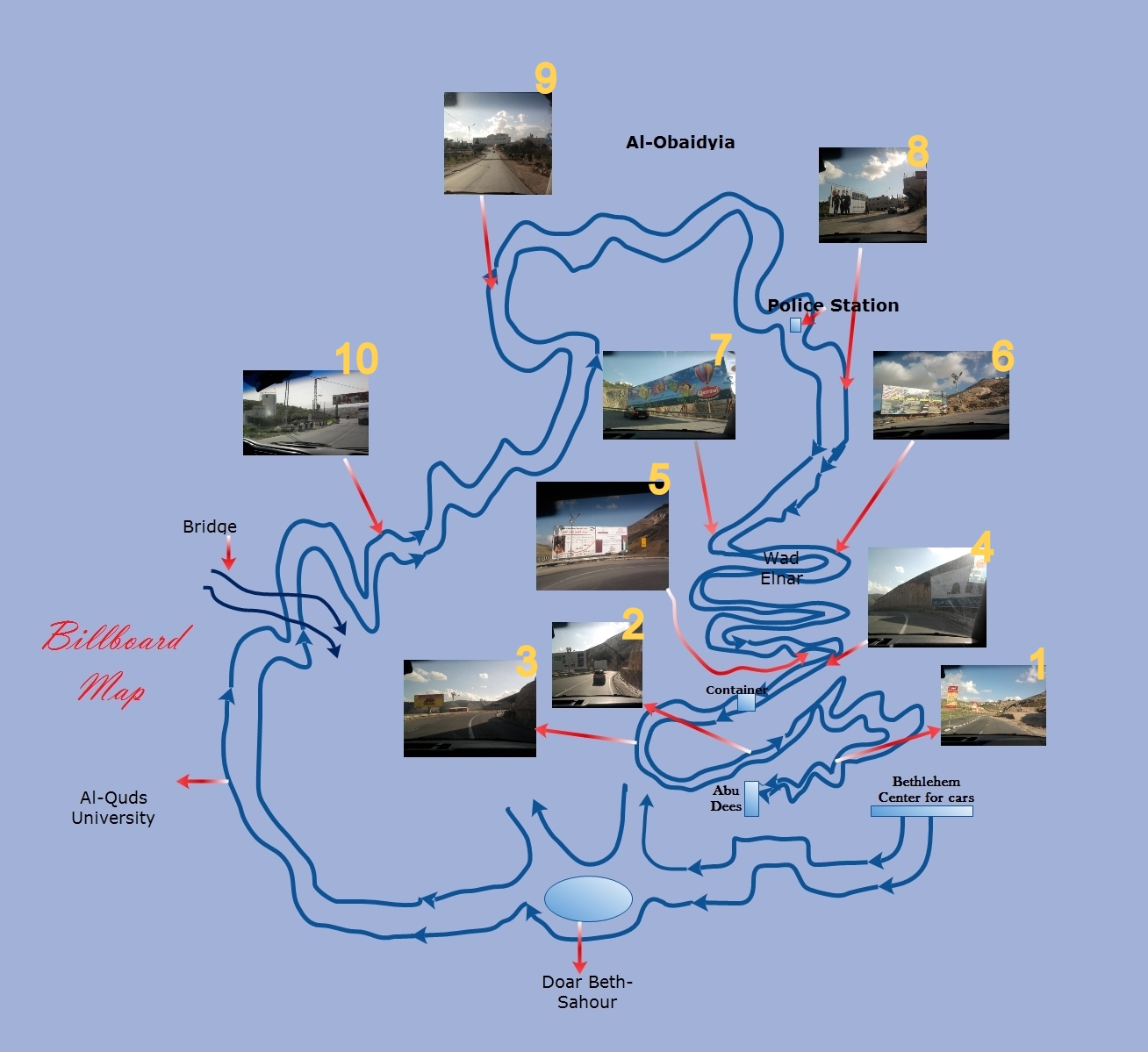
Tuesday, April 24, 2012

Mae Shuaib, Ein Yabrud:Euphoria a piece of heaven on earth

Mae Shuaib:


http://www.youtube.com/watch?v=Tm_qU4IGBYo


(Intro)

Ein Yabrud a village near Ramallah is interesting for all ages, particularly for an adventurous trip in the valley. Its small and everyone knows everyone. My project will discuss the old areas of the village, not only their significance but their historical relevance for the people. The valley of old houses in Ein Yabrud called Shahoun still exists until today. I don’t live in it or have family living in it but I pass it every day on my way home. My view on the ride home includes Shahoun in the forefront, then Ein Yabrud, then the Ofra settlements in the distance. Beer abo Khasaba is a place for land, cultivating, barbecues and the well people get water until today still. I go there sometimes for fun. It's open, beautiful, vast landscape.

I never pictured my village to be open and vast because I always thought it was a straight two way street village with a couple of stores. My grandfather told me his experience in the village. Just the short area I have chosen to video is beautiful. Its interesting how these certain places still exist/stand, especially the Wade el Kuleya, which is the cave that takes you to Yabrud, where people used to hide from the Israeli soldiers in the past. Beer abo Khasaba still stands today and people go get water there but it is a village no one knows or passes by. People used to live in Beer abo Khasaba only for vacation, during summer time. During the winter people would go back to their homes to sleep because Beer abo Khasaba is an open space. No water in village so they go back to Beer abo Khasaba. Cooking was done in the cave. Many types of vegetables, fruits and trees were produced in the land of Beer abo Khasaba. Since the Ofra settlements established people are not allowed to sleep in Beer abo Khasaba like before. 

This video project will show the significance of one small village, and how the monuments and landscape are useable and pretty. Using my grandfather as an example shows the relationship the teenagers and elders, and how we both use the same space.

Wednesday, April 11, 2012

Atlas of senses demonstrate observing our senses on the way from Ramallah to Abu dis with a timed map on each point, and I intent to develop my work with a video titled with the different senses we use like the smells we smell on the way, the sound and what I hear along the ride.

Time - 8:30

In the Mujamma3-
Sounds: taxis beeping, taxi drivers shouting for their destination
Smell: Coffee, fuels, smoke

From the Mujamma3- Al manara square
Sounds: guy selling tea, cars, little kid crying, Fairouz on the radio
Smell: Fresh bread, toasted coffee beans,
taste: xl
sight: cars, passengers, lions on the manara, lines on the atm machine

Qalandia
Sounds: annoying music from the radio, a girl on the phone, taxi driver talking to the guy next to him
Smell:  old books, girls perfume, sewage, dust
Taste: none
Sight: traffic, graffiti on the separation wall, guys from the camp trying to organize the road, trash on the road, rocks and burning buildings from a previous demonstration

Qalandia- Jaba3

Sight: guy selling vegetables, a small car selling tea and coffee, broken cars, dead dogs, Jaba3 checkpoint, israeli soldiers

Touch: seat belt

Jaba3- Hizma

Smell: dust, sweat
Sight: check point in Hizma, separation wall, yellow plate cars in traffic
Sound: disturbing radio presenter with a weird squeaky voice

Jericho st-
Sight: beautiful nature
Smell: smell of a hot breeze, car exhaust
Sound: people exhaling

Ezariye- university
Sight: settlements, a piece of Jerusalem
Sound: coins to pay for the taxi
Smell: sewage, animals


Imad Adwan


My Neighborhood’s Map

            Israel has been building settlements; walls; trenches; checkpoints; electrified and razor wires, and also military roads, as part of its policy to control after the occupied to the Palestinian territories 1967, under what known now as the 'Matrix of Control' to keep the 'security' of Israel, as Wendy Pullan said, "Israel has imposed an increasingly violent and oppressive occupation for nearly 40 years, it is particularly the Palestinians who suffer from what can called an 'asymmetrical' conflict, and are subject to imposed shifts in their own geography that are often incomprehensible and badly damaging to their well-being." She continued, "Israeli territory is also geo-politicized so that aspects of Israeli civilian life are eclipsed by security restrictions, and by the population's own fears and distrust." (261, Contested Spaces) Dr. Michael Ryce defined Violence when as he said, "Violence is an attempt to control. The more insecure or out of control people feel, the more violent will be their thoughts, words and actions." (Page 2, Why is This Happening to Me Again…) The violence which has took a place in the political plan of the matrix of control on the Palestinians both Muslims and Christian. Living as a Palestinian and facing the occupation's Policies towards the West Bank and Jerusalem; also living towards my town, and my neighborhood in particular, which is located between Jerusalem and the West bank, affected and changed my way of looking at things in my neighborhood, and changed my point of view about living in the prison of the Jerusalem-West Bank, and Jerusalem-Bethany at the same time.
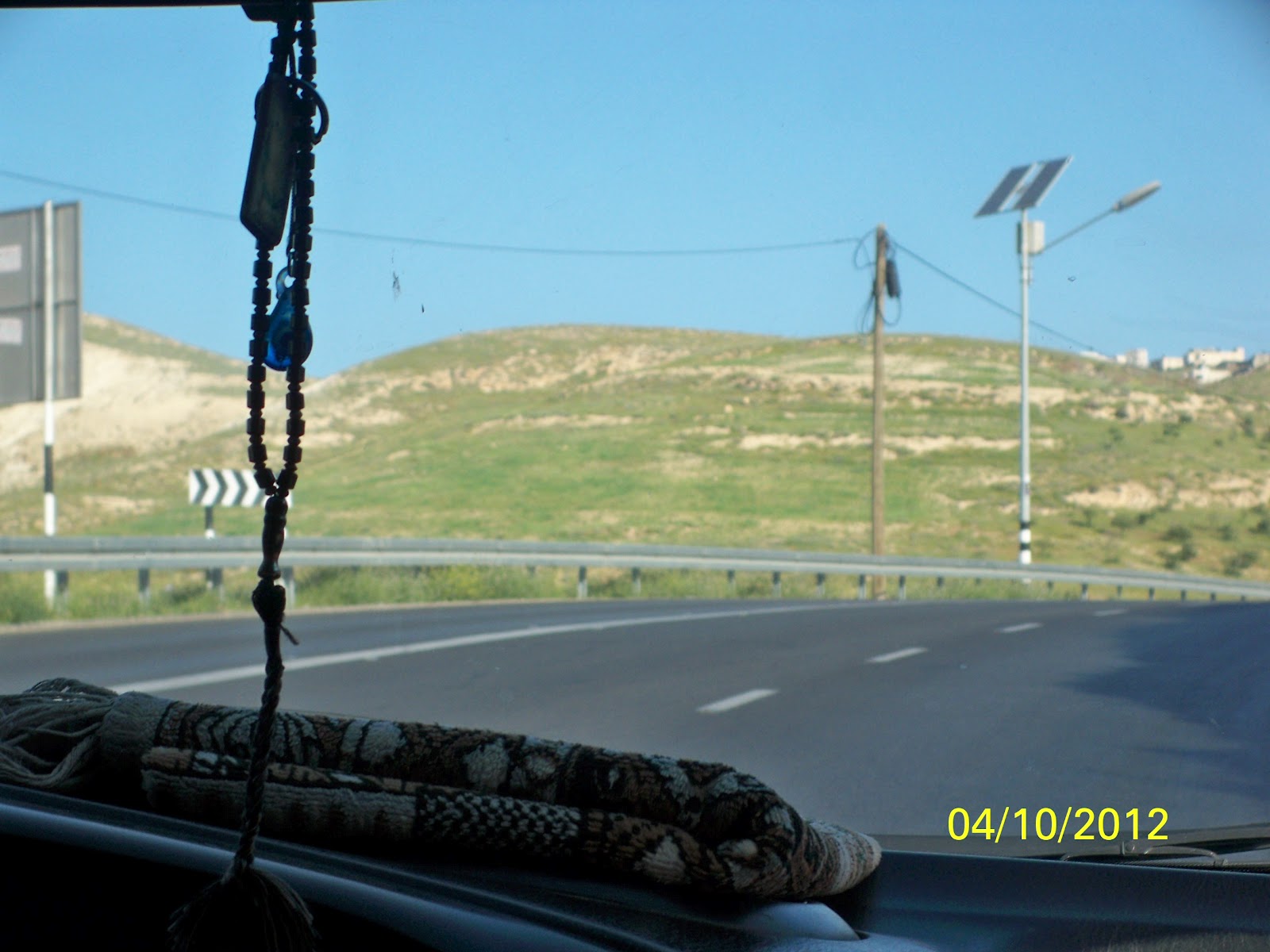
I usually walk into my neighborhood peacefully thinking of the wall which was built to separate the town from Jerusalem. In this paper I am trying to show the details of my neighborhood where I live in a town called Bethany or Lazarus the historical name for the town.
Bethany which is two kilometers away to the East of Jerusalem. My neighborhood which is located now in area used to be known as Albawaba, which means the Gate; although it was not actually a gate, it was just a path to Jerusalem controlled by the Israeli army. It was the main Path for the West Banker of Bethany inhabitants to reach their jobs, schools, or even hospitals in Jerusalem. After starting building the Separation Wall in 2002 what made Bethany surrounded by a wall of apartheid from three sides the Western and Eastern, Southern and today the town's people live in a big prison.
The plan was not only to divide our neighborhood, or dividing my town, its major plan for the whole area, so after dividing Palestine and made it up of two parts, West Bank and Gaza Strip, the plan was to divide the West Back and divide the cities of it.
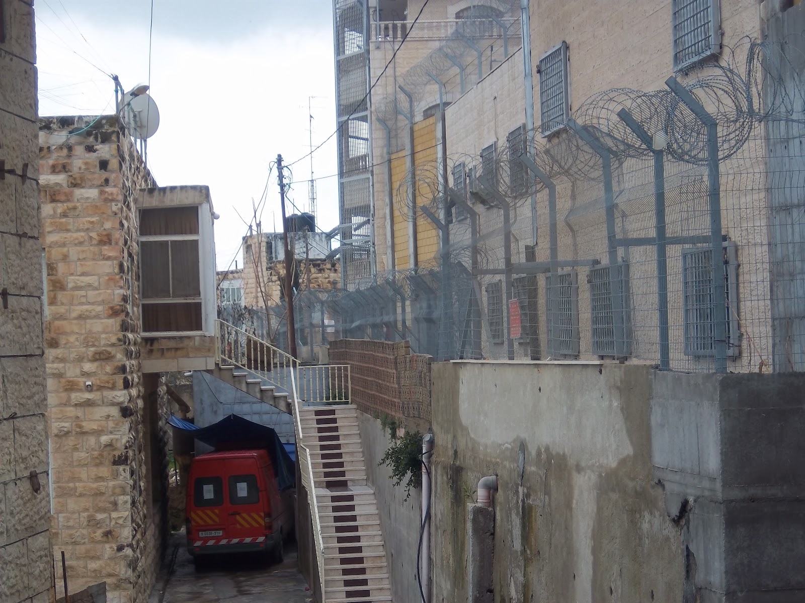
A house that now part of the wall itself where its residents live in their house that part of the apartheid wall where the house balcony is stretched among the wall and the barbed wire there are many reasons why my father choose that Bethany, and that neighborhood exactly to live in. But the main reason simply can be referred to Allan Jacobs and his book looking at Cities where he started his argument in the first chapter when he said, "You can tell a lot about a city by looking."  My father simply looked at the area, and it was the best decision to take at that time; a West Banker live ten minutes away from Jerusalem by car. Where his job, his children schools and his life city center the only place where he is in Jerusalem and West Bank at the same time.
Albawaba was the gate to Jerusalem for many years till they established Alzayton checkpoint. Students and teachers going to their schools, doctors or patients heading to the main hospital for the Palestinians in the West Bank Almakased hospital, and also the old ladies with the big bags upon their heads, filling with anything they produce or buy, to sell them in Jerusalem streets, all kinds of people used to come through Albawaba to reach Jerusalem.
Every Morning I wake up to start my day like I'm going out of a prison, by walking next to a huge wall was built by the Israelis just next to our house. And see the same view of the real occupation image, where the first thing I see when I look through my window or get out of my house is the huge wall and the control tower. A scary gray concrete tower with colored patches of paint, from the angry Palestinian opponents of the apartheid wall. The tower was built in the form of cylindrical on the top of it there are windows that allow to the soldier inside to see when nobody outside the tower can see if there is someone inside looking or not so all the time people act like there is always someone inside watching them, and their movements. For me too I don’t feel comfortable when I stand in front of the window in my room, where the curtains are usually closed, and if I was taking his path out of the neighborhood in front of the tower I walk fast. Next to that tower, there is a huge gate that can allow for a big tank to go though it easily.
While walking in the streets of that small neighborhood there are many things can't be seen anywhere else in the world, no such humiliating treatment for the people. One side of the neighborhood you see the mosque of Lazarus and the church of St. Lazarus are hugging each other. And on the other side, the one can see the hooligan activities of the Israelis toward the religious places to both Muslims and Christians of confiscating some of the lands of monastery of AlbasionstAnd the monastery of Alfrcescan (Der Biet Faga) was made as a prison by surrounding it of the wall and cutting the Historic monuments in Bethany from each others and divided the whole area.
The cemetery of Bethany is in our neighborhood there, where I see it everyday, and see the part of death, in this life. Some of the graves were destroyed to complete building the humiliating wall. Many other images you can see in my neighborhood, like the green ID inhabitant that living inside what's now known as Jerusalem and before a year it used to be part of our neighborhood in the West Bank. Our neighbor's life all in Bethany, the place where he and his family decided to live but the plan of construction of the wall put them in the other side of the wall where they are now in Bethany and Jerusalem at the same time, their names are written in that gate, and that’s the only place they can enter their houses if they were in the West Bank, and it's a very difficult process to have guests in their house because they need to have permit to get into that small gate that lead to a whole world behind it.
There is. And the same morning at the same time the soldiers open the gate twice for the children of Kindergarten in the other side of the wall. One time it opens about eight O'clock in the morning, and another time at one in the afternoon. The wall didn’t even have a mercy for the small children that go to the kindergarten where the apartheid wall is part of the kindergarten construction.

Hana' Salamah, Billboard Map


Billboard Map


                 Either be decorated on the doors of the shops or be hung on the columns on the streets or painted on walls in the main streets. The purpose of all of this is to reach every home and thus to get people interest to buy it. The important thing is to presented it in a way that dominated by art, quality, high technology and how to enter every home and make it wanted by everyone. Commercials signs sometimes contribute significantly to the marketing item for local and global consumption. My project will discuss the idea of billboard and what they represent. Also I will show a map with billboards on it as sign. The point of the billboard is to get noticed. It also depends on what is on that billboard, what attracts people. These signs that we see in the way has significance role, this connotation may not be profitable for the company, but they are useful to the traveler who passed a lot of experiences in his way. So these signs were a way to escape from them. I will show the billboard sign that I see always when I leave Abu Dees to Bethlehem.  The billboards on this map represent a mark or a historic place that lead traveler to their destination.. Finally, I will show some of the original location of these billboard and the places that produce them. Also I will represent a video that describe Al-haj Mohammad Hassan opinion about billboards. 


(http://www.youtube.com/watch?v=gu2hr81L4Es) click on this link to see the video


Picture one: 
        
           This image shows the first sign you will see when you leave Abu Dees as a historical places. This sign may help traveler in their destination and it has no negative aspect because it is in the middle of the street and   it capture people's awareness because they will be in the road for half an hour to reach Bethlehem.      


1


Picture two, three, four and five:
          
             In these photo, the number of billboard increase because it a wide and long road before Wad El-Nar.As shown in these image, these sign are located after the Container checkpoint. These signs draws people's attention and give a view of the street. The company puts these billboard on this wide road to let people know or give them information about it. Thus people will be interested to visit these places.  


2


3

4

5

http://www.ruspal.net/ a website describing this billboard and what this company is doing. 


Picture six and seven:
        
             In these images, we are in Wad El-Nar road and as we see there is a lot of billboard in this road. These billboards give a beautiful view for the road.When we look in these sign we feel happy as if we are in this place and it is easily accessible but in the fact it will be far away. It may entertaining you and let you think of something else if you have problem.    

video about this place in Hebron.  
6

 http://www.al-qasrawi.com/en/about-us.html (The website of this company)


7 


Image eight:

              This billboard is located in the road near police station after Wad El-Nar zigzag road. Billboard may have a negative aspect especially on the road. Sometimes putting billboard in the road may obscure the landscape that most people enjoy and love to see it instead of a large cartons that lot of people may not notice it and they think that it is boring and causing financial loss. 

 http://www.heliopolis.ps/ this is the website of this trade market.


8


Picture nine and ten:

               we are approaching Beit Sahour to enter Bethlehem. These billboards has a significant and physical role and they can be easily remembered. It will spread awareness about this business or this company.there is a negative point about billboard is that it can distract the driver so it must be placed in where the traffic is expected to slow down. Parking lots of shopping malls are also popular places used by billboard companies. 

9

10


               In my opinion, Billboard are a great way of informing the public of promotional events such as sales or of a new product launch and seem to motivate people to take action. This seems to be especially true for people who repeatedly view  billboards.


Tuesday, April 10, 2012

My project will discuss the topic on the tower and the idea of an "eye" watching you. This idea has then lead to the description of the panopticon, which was first invented by Jeff Bentham. This concept was brought up in order to be watched everywhere and at all time. The panopticon has been used in prisons, schools, and hospitals back in the past. However, today's use of the panopticon can be found everywhere, by cameras, towers, and the idea of internet being watched. In our society, the use of the tower is more focused on, which is found usually near checkpoints and containers used by the Israeli soldiers. The use of the tower on it cameras from all sides, is a way to show how much power they have and how we Palestinians are being watched. The towers might have someone in it and might not, but whenever we see one we automatically assume we are being watched. This notion brings us to act in a specific way and try not to do any specific actions that may attract the soldiers to stop us. Also, Palestinians are not allowed to get close to the tower or there would be serious consequences. I will depict photos of where the tower can or cannot see the taxis driving through Wadi El-Nar. 

This is a photo I have drawn of Wadi El-Nar and which spots the tower can observe us and when it can't.


Now this photo will show the first picture of where the panopticon-tower cannot see us.


PICTURE 1: As shown in this photo, this is the beginning of Wadi El- Nar and one can see that the tower  is shown from far away.


PICTURE 2: In this photo, one may see that the tower cannot see the taxis because of the angle and the hills covering us. 


PICTURE 3: Again in this photo the tower is not shown and cannot see us.

PICTURE 4: The tower is still not shown.


PICTURE 5: In this picture, one can see how the tower is shown, and how we are beginning to be watched from this point.


PICTURE 6: As we approach the checkpoint the tower is getting closer and we are being watched.


PICTURE 7: This photo shows how the tower is watching every move the taxi makes.


PICTURE 8: As shown in this picture, one can see how close we are to the tower and how the cameras are pointed directly towards us, which makes us watch our every move.


PICTURE 9: Directly next to the tower.


The idea of this project is mostly aiming how Palestinians are constantly being watched by the Israelis no matter where or what we are doing.

Nicole Kasbary. 


Monday, April 9, 2012

Renna Totah, Map of Sounds


Renna Totah

  Intro:    Our senses usually steer us in a certain direction. Like in cartoons, how one character would be lead by their sense of smeel to the yummy food. The following is a video which traces a map from my home to Abu Dees by the hearing of sounds. Each sound that is heard represents what i am hearing in the photagraph that is shown. The purpose of this project is to demonstrate how one could follow sounds to their destination instead of using an actual drawn map. Also, the sounds represent what I hear mostly everyday that people, for instance, living in Ramallah might not ever hear. Sounds can lead you wherever you want to go, it will steer you in the right direction. So sit back and enjoy the mapping of sounds in Jerusalem.

Discussion:    As shown in the audio, sound can lead you to a certain destination. People usually draw, take a picture, or video to view there destination. In this project, I focused on one of the five senses, the sense of sound. Humans tend to use visual maps to show where they are going. In this project, sounds is the only sense that is used. As you notice in the audio, many sounds are different, but most are very alike. In the beginning, we hear the sounds of birds chirping. Further on in the audio, we start to hear cars. From this point of the audio, many of the sounds are extremely similar. Even though i am walking to different places, many places have the same sound. Even though they are very similar, each place has a certain sound in a particular moment. Edward Said has said "But what interests me is the hold of both memory and geography on the desire for conquest and domination..."(Page 247) Here we can see maps are tied in with the memory of how the actual place looked like. Memory of a place makes you attatched to it in a way. Sound works the same way. We all remeber how a door bell rings without even atually hearing it, or a lions roar. This is all in memory. So as the sounds you hear mostly everyday, steer you to a certain direction. edward Said mention's "The concern of memory, for example, has branched out to include such increasingly prevalent forms of writing..." (Page 241)Their are many forms of memory. I have explored the memory of sound. The sounds that you are hearing in this audio, I have been hearing these sounds for a long time. So to me, they have started to become a memory of mine that I will never forget. I will never forget the beautiful sounds of Jerusalem.

Test / Area C

Tower


This is...